Coastal Construction
 Coastal Construction is regulated by a variety of jurisdictions. The State of Florida has established Coastal Construction Control Lines (CCCL) on a county-by-county basis to define that portion of the beach-dune system which is subject to severe fluctuations following major storm events. The purpose of the CCCL is to preserve and protect coastal barrier dunes and adjacent beaches from imprudent construction which can jeopardize the stability of the beach-dune system, accelerate erosion, and provide inadequate protection for upland structures.
Permits from the Florida Department of Environmental Protection, Bureau of Beaches and Coastal Systems are required for most structures constructed seaward of the established CCCL.
Limited exemptions from permitting requirements are available. For example, the modification, maintenance, or repair of existing structures within the limits of existing foundations, which do not result in any addition to, repair or modification of the foundation itself, is exempt. Additionally, additions or enclosures added above the first dwelling floor may also be exempt from CCCL permitting.
DEP regulations specify detailed siting and engineering design criteria which must be satisfied before a permit will be issued for construction seaward of the CCCL.
Typically, for example, a proposed residential structure must be located as far landward as possible, must not advance an existing line of construction, and must be elevated above the calculated storm surge and wind driven waves associated with a 100-year storm event. The structure must be constructed on pilings with ground level walls constructed of breakaway material. Under the Statewide Florida Building Code, the technical construction details applicable to structures to be constructed seaward of the CCCL are regulated through the building permits required by counties and municipalities.
As noted above, structures to be constructed seaward of the established CCCL are required to be elevated upon piles. The piles are to be designed to be embedded deep enough to remain structurally sound after the predicted loss of several feet of soil during a hurricane event. The structure is required to be elevated to a height such that the water associated with a hurricane storm surge and wind blown waves can pass safely below the first horizontal beam supporting the living floor of the structure. This elevation, called the “design storm elevation” or “100-year elevation” is measured from the bottom of the first horizontal structural member to mean sea level.
In 2002 following refined computer modeling, the FDEP revised its minimum elevation requirements increasing the predicted height of the “100 year storm” elevation. The legal effect of this modification was to make all structures previously permitted to lower elevations as legally non-conforming.
It may not be permissible to expand existing nonconforming structures beyond the existing footprint and at the same non-conforming elevation if the cost of the proposed improvements equals or exceeds 50% of the fair market value of the non-conforming structure prior to the improvement.
Buyers of existing structures seaward of the State CCCL are advised to have a surveyor determine the elevation of the first horizontal beam and compare this elevation with the State’s current 100-year storm elevation.
In addition to the CCCL, the Florida Legislature has established the 30-year Erosion Projection Line. This line establishes the predicted shoreline thirty years into the future based on site specific historic erosion data. Florida law prohibits any new construction seaward of the 30-year erosion projection line. A limited exception to this prohibition is available to allow the construction of a single family residence if the location of the line would otherwise prohibit the construction of such residence on the property. Only that amount of encroachment beyond the line that will allow a reasonable use of the property will be permitted.
Buyers are advised to have the location of this 30-year Erosion Projection Line surveyed prior to purchase.
Counties and municipalities also regulate coastal construction by incorporating within local building codes regulations established by the Federal Emergency Management Agency (FEMA). Local enforcement of FEMA regulations is required to enable local governments to participate in the National Flood Insurance Program affording federally subsidized insurance to its residents.
Counties and municipalities may also impose their own setbacks from the Atlantic Ocean or Gulf of Mexico to limit the seaward location of residential structures. Sarasota County, for example, has established a Gulf Beach Setback Line, located between the mean high water line and the state CCCL.
While the State CCCL is a line of permitting jurisdiction, Sarasota County’s Gulf Beach Setback Line is a line of prohibition. According to Sarasota County’s Ordinance, construction seaward of the Gulf Beach Setback Line is prohibited.
Sarasota County does exempt from its prohibition certain minor structures such as decks, dune walk-over structures, and stairs. Construction of residences seaward of the Gulf Beach Setback Line may be conducted only if a variance is granted by the Sarasota County Board of County Commissioners upon a demonstration of an “unusual hardship”.
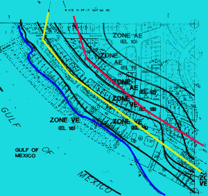
The relative location of jurisdictional lines within Sarasota County is depicted above. The red line represents the location of the State Coastal Construction Control Line. The yellow line is the Sarasota County Gulf Beach Setback Line. The blue line is the location of the mean high water line.
Buyers are advised to check with their local jurisdiction to determine the existence of any local setback requirements and the effect of such requirements on development plans.
FEMA Regulations
The goal of the National Flood Insurance Program (“NFIP”), administered by Federal Emergency Management Agency (“FEMA”) is to reduce losses through regulation of construction. FEMA regulations are enforced by local communities through building and zoning codes.
The primary objective of FEMA is to elevate the habitable portion of structures above flood waters.
FEMA prepares Flood Insurance Rate Maps (“FIRM”) delineating flood risk zones. Properties along the Atlantic Ocean and Gulf of Mexico are typically located either in a FEMA “A” Zone, or “V” Zone, or both.
As depicted in the figure above, FEMA “V” Zones reflect areas which are subject to flood waters with the greatest velocity, i.e., closest to the Ocean or Gulf. FEMA “A” Zones are generally located immediately landward from FEMA “V” Zones. Each Zone has special construction design requirements for structures to be located within said area.
FEMA regulations are designed to require vulnerable structures to be elevated above the flood waters associated with a 100-year storm event, the “Base Flood”. FIRM maps depict the required Base Flood Elevation (“BFE”) associated with the designated FEMA Flood Zone. The parenthetical number shown with the designated FEMA Zone on the figure above represents the applicable Base Flood Elevation, i.e., the predicted height above mean sea level of either a 100-year flood, in the case of FEMA “A” Zones, or the 100-year storm surge, in the case of FEMA “V” Zones.
FEMA “A” Zone Restrictions
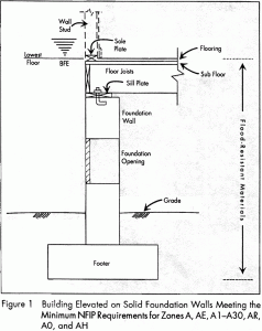
In an “A Zone”, the top of lowest habitable floor must be elevated to or above the required Base Flood Elevation (“BFE”).
Areas below the BFE can only be used for parking, storage, or access.
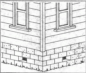
Walls below the BFE must have openings (shown as “foundation opening” above) to permit entry and exit of flood waters.
A typical conforming house in an “A Zone” would look like this:
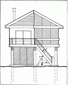
FEMA “V” Zone Restrictions
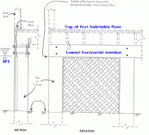
In a FEMA “V” Zone, the bottom of lowest horizontal structural member supporting the lowest habitable floor must be elevated to or above the BFE. The space below the BFE must be free of obstructions. Areas below the BFE must be used for open space, storage, or access. Standard electrical outlets, appliances, air conditioning equipment, and bathrooms are prohibited below the BFE. Walls below the BFE must be of break-away design.
A typical conforming house in a FEMA “V” Zone would look like this:
ALL NEW STRUCTURES BUILT AFTER JANUARY 1, 1975 AND ALL “SUBSTANTIAL IMPROVEMENTS” TO EXISTING STRUCTURES MUST CONFORM TO CURRENT FEMA FLOOD ZONE RESTRICTIONS.
STRUCTURES AND ADDITIONS WHICH DO NOT CONFORM TO FEMA RESTRICTIONS MAY BE ILLEGAL.
FEMA 50% RULE
Any reconstruction, repair, addition or other improvement, the cost of which exceeds or equals 50% of the market value of the structure before the start of construction, is deemed to be a “substantial improvement”.
If the improvement exceeds or equals 50% of the market value of the structure, the existing structure must the brought into compliance with FEMA regulations.
Local jurisdictions have different rules regarding the calculation of the 50% rule after the issuance of the first permit. Buyers are advised to consult with local building officials regarding their redevelopment or remodeling plans. For more information, please see the Power Point Presentation on FEMA Regulations.